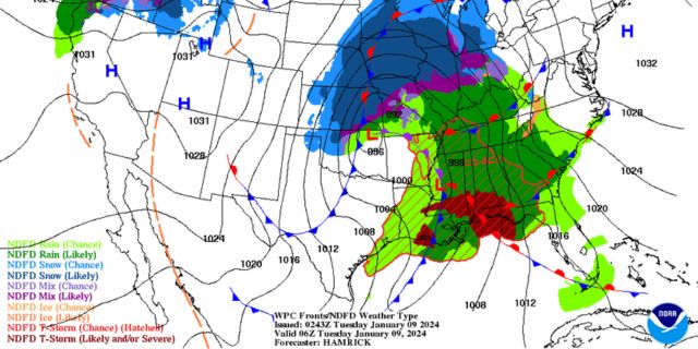
Alabama Skies: A few more storms are on the way Tuesday. Another severe weather event is possible later this week. Plus, snow in the forecast?
Published 9:08 pm Monday, January 8, 2024
Some of us will have a few more hours to deal with some potentially rough weather early Tuesday and Tuesday morning before we dry out with cooler temperatures and strong, gusty winds. Once we get this strong cold front out of the way, we’re already looking ahead at the potential for another severe weather event in just a few days.
Our cold front brought some much-needed rainfall with a few flooding problems, plus tornado warnings, power outages, and hail. We’ll have some more power outages possible as the entire state will have strong, gusty winds Tuesday with wind gusts up to 40 miles per hour.
These are gradient winds and are possible away from showers or storms.
Trending
After we dry out a couple days, we’re watching our next system coming into the region Thursday night or Friday. The Storm Prediction Center has already placed much of the state under a Level 2 risk.
North Alabama
Showers early with a high of 54. Gusty winds. Tuesday evening, a few showers, possibly mixing with snow after 9 p.m. Cloudy overnight with a low of 31.
Central Alabama
Showers early with temperatures falling into the 40s throughout the day. Breezy. Mostly cloudy Tuesday night with a low of 32.
South Alabama
Showers and storms in the morning, then rain until around noon. A storm or two could be strong to severe. Temperatures falling to around 50 in the afternoon. Mostly cloudy overnight with a low of 33.
Gulf Coast
Showers and storms in the morning. A few storms could be severe. Temperatures falling to around 50 by late afternoon. Mostly clear Tuesday night with a low of 34.


