Alabama Skies: Severe weather threat arrives with front
Published 11:40 pm Thursday, March 7, 2024
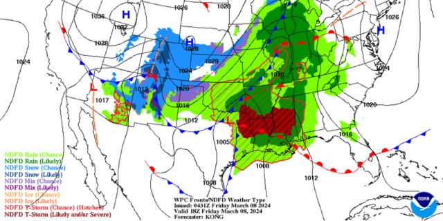
We’ve been watching how models were handling the approaching front for several day and it’s finally time for the potential weather threat to arrive.
In northern parts of the state, we can expect heavy rain with a few storms. A storm or two could be strong, but the main risk for severe weather is for central and southern Alabama.
The central and southern regions are under a Level 2 risk for severe weather from 6 p.m. Friday until 9 a.m. Saturday. Brief tornadoes are possible with damaging winds.
Once the front moves through, we’re expecting a really nice weekend as we prepare for jumping ahead in time overnight Saturday.
North Alabama
Showers likely, mainly in the afternoon. High of 70. Showers with thunderstorms Friday night. Low of 59.
Central Alabama
Cloudy with showers likely in the afternoon. High of 71. Showers overnight with a few storms possible. Some of the storms could be strong with heavy rainfall. Low of 59.
South Alabama
Cloudy with showers and storms possible, especially in the afternoon. A storm or two could be strong. High of 74. More showers and storms overnight with some strong storms possible. Low of 61
Gulf Coast
Mostly sunny with a high of 78. Becoming mostly cloudy overnight with a low of 58.


