Alabama Skies Bulletin: Severe weather risk increases, begins overnight
Published 5:29 pm Friday, January 26, 2024

- The risk for severe weather is increasing for our southern counties.
We’re watching the potential for some severe weather beginning as early as 5 a.m. for parts of Alabama.
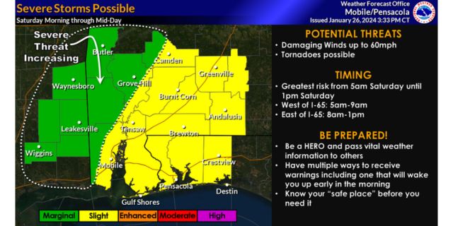
One of those areas, highlighted in the graphic, is being watched by the National Weather Service in Mobile/Pensacola for an increasing threat.
“A line of storms will slide across the area early Saturday morning into mid-day,” information from the NWS reads. “Damaging winds and tornadoes are possible with this line of storms. The greatest threat is from 5 a.m. until 9 a.m. for locations west of I-65 and 8 a.m. through 1 p.m. east of I-65. Be a Hero and pass vital weather information along to others. Have multiple ways to receive warnings, including one that will wake you up early in the morning. Know your safe place before you need it. For more information, go to our Facebook and Twitter pages or listen to NOAA Weather Radio.”
The risk begins farther north to the Demopolis to Auburn line around 7 a.m., but the chance for tornadoes and severe weather isn’t as high.
We’ll have another round of potentially severe storms in the afternoon. This round will include most of the state with a Level 2 stretching through the central part of the state all the way from the coast to Gadsden.

