Alabama Skies: More flooding, tornadoes possible with next round of stormy weather
Published 9:20 pm Thursday, January 25, 2024
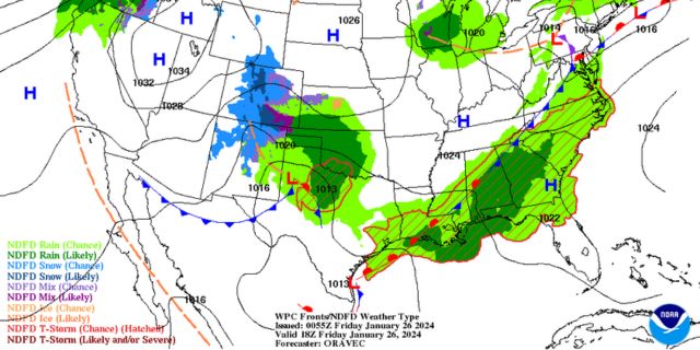
Northern Alabama will get a little break from the rain Friday, but the rest of the state will continue dealing with several waves of heavy rain. Rain will return to northern Alabama Friday night.
Although Friday will feature plenty of chances for rain for some of us, the chance for severe weather comes to a large portion of the state Saturday.
According to the National Weather Service, there are two risk levels. A Level 2 risk covers a swatch through the state and includes Anniston, Clanton, Alexander City, Auburn, Selma, Montgomery, Troy, Camden, Burnt Corn, Andalusia, and Greenville.
In the Level 2 zone, the greatest risks are brief tornadoes and damaging winds.
A Level 1 covers both sides of the Level 2 and stretches from Jasper to Foley. The threats are the same without as much confidence.
The risk for severe weather is late Saturday morning into the afternoon.
“Several rounds of rainfall are expected to impact the region through Saturday,” a statement from the NWS reads. “There could be large differences in rainfall totals across short distances. There is a limited risk of flooding, primarily in urban and low-lying areas, as well as areas that are saturated from recent rainfall. Never attempt to cross flooded roads.”
North Alabama
Fog early. Partly sunny skies during the day with a slight chance of a shower in the evening. High of 64. Showers likely overnight with a thunderstorm possible. Low of 54.
Central Alabama
A chance of showers throughout the day with thunderstorms possible in the afternoon. Cloudy with a high of 68. Showers and thunderstorms overnight with a low of 58.
South Alabama
Showers are likely with a thunderstorm possible. High of 70. Cloudy overnight with a few showers or storms possible. Low of 60.
Gulf Coast
Showers likely with a few storms possible. Fog in the morning. High of 70. Showers continue with a few thunderstorms overnight. Low of 62.


