Alabama weather may get nasty this week as severe storms threaten flooding through midweek
Published 10:48 am Monday, February 10, 2020
In addition to the ongoing flooding concerns from the Deep South to the Tennessee Valley and mid-Atlantic, severe thunderstorms may also threaten Alabama Wednesday.
Residents across much of the lower Mississippi River Valley through the Southeast coast have already been on alert following damaging winds and tornadoes that swept through the area last week.
Some parts of the South won’t have to wait until midweek to be on alert for disruptive storms. An initial round of severe weather is expected into Monday evening from eastern Texas to southern Mississippi.
For the start of the week, the main threats will be flooding downpours, hail and damaging wind gusts.
A widespread tornado threat is not expected, but an isolated tornado or two cannot be ruled out, according to AccuWeather Meteorologist Brett Edwards.
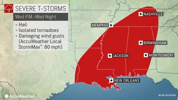
A more elevated threat of tornadoes, with more widespread severe thunderstorms, will wait until Wednesday.
The same storm that is bringing snow to the southern Rockies and Texas, after unleashing damaging winds in California over the weekend, will move into the Deep South Wednesday.
“As the storm intensifies over the Southeast on Wednesday, it will draw a lot of moisture up from the Gulf of Mexico. These ingredients will help to prime the atmosphere for severe weather on Wednesday afternoon and Wednesday night,” said Edwards.
In addition to damaging wind gusts and hail, there will also be the potential for isolated tornadoes to develop.
Communities from New Orleans to Nashville should be mindful of the weather around them and have a plan to shelter in place should it be needed in case a tornado warning is issued.
Motorists along parts of interstates 10, 20, 40, 55 and 59 should also be aware of thunderstorms in the area for the evening commute, as gusty winds and torrential rains could significantly lengthen travel times.
Downpours will continue to bring the risk of both flash flooding and river flooding to the already saturated region through Wednesday night.
Travelers should remember that floodwaters over roadways are dangerous to drive through. The water can disguise a washed-out road and take control of a vehicle with only a few inches of water.
By Courtney Spamer, AccuWeather meteorologist