James Spann: Chance of severe weather tonight across portions of Alabama, stay awar
Published 10:21 am Monday, December 16, 2019
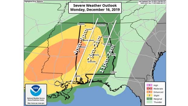
A dynamic weather system will bring the threat of strong to severe thunderstorms to Alabama late this afternoon and tonight. The Storm Prediction Center has some western counties in an enhanced risk (level 3 out of 5) of severe storms. A slight risk (level 2 of 5) is defined as far east as Huntsville, Gadsden, Alexander City, Troy and Andalusia, and the rest of east Alabama is in a marginal risk (level 1 of 5).
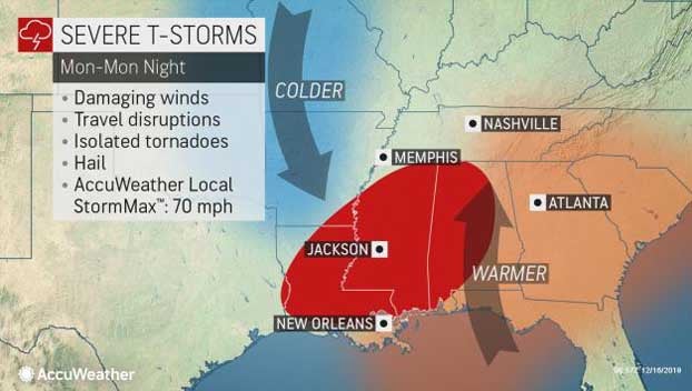
There will be sufficient instability and shear to support severe storms on a large scale. There are still some questions concerning how the mesoscale features play out tonight, but certainly everyone in Alabama will need to pay attention to the weather and heed warnings if they are issued.
TIMING: A few severe storms are possible over far west and northwest Alabama as early as 4, but the core threat comes tonight, after 6. Storms could linger across east and southeast Alabama through 7 a.m. Tuesday.
THREATS: Storms tonight will be capable of producing large hail, damaging winds and a few tornadoes. For now the SPC shows the higher tornado probabilities west of Alabama over parts of Mississippi and Louisiana.
RAIN: Rain amounts of 1-2 inches are likely for most of the state through Tuesday morning. No major flooding issues are expected.
CALL TO ACTION: Be sure you have a way of hearing severe weather warnings tonight if they are needed. Never rely on a siren. Every Alabama home and business needs a NOAA Weather Radio, properly programmed with a fresh battery backup. Have Wireless Emergency Alerts enabled on your phone, and download the free ABC 33/40 Weather app to get notifications as well (just search for it on the App Store). In your safe place, have helmets for everyone, including adults. And if you live in a mobile home, you have to leave if you are in a tornado warning polygon; know where you are going and the quickest way of getting there.
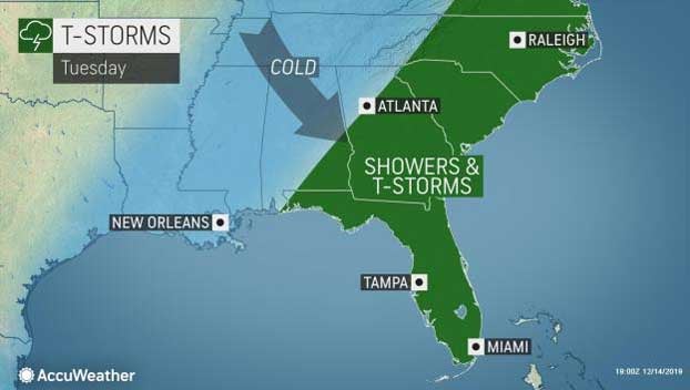
REST OF THE WEEK: Tuesday will be mostly cloudy and sharply colder; temperatures over the northern half of the state hold in the 40s all day with a chilly northwest wind of 15-25 mph. Some lingering rain is possible Tuesday morning over the southeast counties. Wednesday and Thursday will be dry with a good supply of sunshine both days; morning lows will be in the 20s. The high will be close to 50 Wednesday, followed by low 50s Thursday.
High clouds will move in Friday ahead of an upper air system, but the sky will be partly sunny with a high in the 50s. It looks like the air will be too dry for any meaningful chance of rain.
THE ALABAMA WEEKEND: The weekend will be dry and pleasant with mostly sunny conditions both days; the high will be in the low 60s Saturday, followed by mid 60s Sunday.
CHRISTMAS WEEK: An upper ridge will likely keep the weather dry and pleasant much of the week. Temperatures will be above average with highs in the 60s. If you are looking for a white Christmas, don’t look anywhere in Alabama.
Republished from the Alabama Newscenter.